
Informations
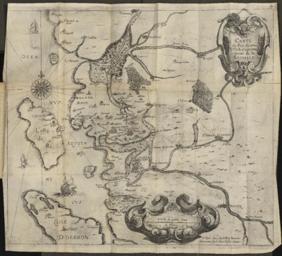
Carte du pais d'Aunis ville & gouvernement de La Rochelle.
Author(s), creator(s), collaborator(s) : Bachot, Jérôme
Type of the represented object : Map
Permalink
https://hdl.handle.net/2268.1/8044
Détails
| Other title: | Carte du pays d'Aunis ville et gouvernement de La Rochelle |
| Author(s), creator(s), collaborator(s): | Bachot, Jérôme (1588?-1635) (author) |
| Editor: | [Paris] A Paris, chez Melchior Tavernier, demeurant sur le Pont Nostre Dame. |
| Place of creation of the original object: | Paris (France) |
| First publication of the original object: | 1621 17th century Modern times (1492-1789) |
| Original object location: | Réseau des Bibliothèques |
| Identifiant(s): | XXII.87.8(E)(Guerre 3) [16°] (Cote ULiège) 700602222 (Code-barres ULiège) |
| Original object language: | French |
| Material, support of the original object: | Papier 8° |
| Dimensions, weight or duration: | 40 x 42 cm |
| Physical description of the represented object : | 1 carte |
| Description: | L'ouvrage à la cote XXII.87.8(E)(Guerre 3) [16°] en ALPHA-Site central est relié avec "Recit veritable de la prise, par force, de la ville d'Albiac pres Montauban et punition des habitans d'icelle, mis & taillez en pieces, pour cause de perfidie & rebellion par Monsieur le duc de Mayenne."
Description physique : Échelle de quatre lieue de Poittou [1:249000 environ] |
| Keyword: | Aunis (Charente-Maritime) -- 17e siècle -- Cartes; La Rochelle (Charente-Maritime) -- 17e siècle -- Cartes; Cartes anciennes |
| CREF classification(s): | Histoire |
| Classification(s): | Arts & humanities => History |
| Part of: | Public domain |
| Permalink: | https://hdl.handle.net/2268.1/8044 |

Items in DONum are protected by copyright, with all rights reserved, unless otherwise indicated.