
Informations
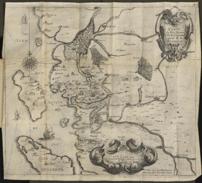
Carte du pais d'Aunis ville & gouvernement de La Rochelle.
Auteur(s), créateur(s), collaborateur(s) : Bachot, Jérôme
Type d'objet représenté : Carte
URL permanente
https://hdl.handle.net/2268.1/8044
Détails
| Autre titre: | Carte du pays d'Aunis ville et gouvernement de La Rochelle |
| Auteur(s), créateur(s), collaborateur(s): | Bachot, Jérôme (1588?-1635) (auteur) |
| Editeur: | [Paris] A Paris, chez Melchior Tavernier, demeurant sur le Pont Nostre Dame. |
| Lieu de création de l'objet original: | Paris (France) |
| Première publication ou diffusion de l'objet original: | 1621 17e siècle Temps Modernes (1492-1789) |
| Lieu de conservation de l'objet original: | Réseau des Bibliothèques |
| Identifiant(s): | XXII.87.8(E)(Guerre 3) [16°] (Cote ULiège) 700602222 (Code-barres ULiège) |
| Langue de l'objet original: | Français |
| Matériau, support de l'objet original: | Papier 8° |
| Dimensions, durée ou poids: | 40 x 42 cm |
| Description physique de l'objet représenté: | 1 carte |
| Description: | L'ouvrage à la cote XXII.87.8(E)(Guerre 3) [16°] en ALPHA-Site central est relié avec "Recit veritable de la prise, par force, de la ville d'Albiac pres Montauban et punition des habitans d'icelle, mis & taillez en pieces, pour cause de perfidie & rebellion par Monsieur le duc de Mayenne."
Description physique : Échelle de quatre lieue de Poittou [1:249000 environ] |
| Mots-clés: | Aunis (Charente-Maritime) -- 17e siècle -- Cartes; La Rochelle (Charente-Maritime) -- 17e siècle -- Cartes; Cartes anciennes |
| Discipline(s) CREF: | Histoire |
| Discipline(s): | Arts & sciences humaines => Histoire |
| Fait partie du: | Domaine public |
| URL permanente: | https://hdl.handle.net/2268.1/8044 |

Les reproductions numériques disponibles sur DONum sont en faible résolution, facilitant le téléchargement. Des fichiers de haute qualité peuvent être obtenus sur conditions, via notre formulaire de contact.
Les documents disponibles sur DONum peuvent être protégés par le droit d'auteur. Ils sont soumis aux règles habituelles de bon usage.