
Informations
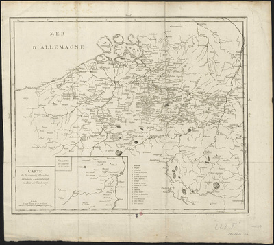
Carte du Hainault, Flandre, Brabant, Luxembourg et Païs de Limbourg.
Author(s), creator(s), collaborator(s) :
Type of the represented object : Map
Permalink
https://hdl.handle.net/2268.1/3794
Détails
| Editor: | [S.l.] : [s.n.] |
| First publication of the original object: | 18th century Modern times (1492-1789) |
| Original object location: | Réseau des Bibliothèques |
| Collection: | Maps |
| Identifiant(s): | 228F (cote ULiège) 1801424-10 (code-barres ULiège) |
| Original object language: | French |
| Abstract: | Echelle [1:560 000] |
| Material, support of the original object: | Papier |
| Dimensions, weight or duration: | 43 x 52 cm |
| Physical description of the represented object : | 1 carte |
| Description: | Légende reprenant les numéros utilisés pour désigner les différents sites
Encart : Villages des environs de Maestricht |
| Geographical Location represent or evoke: | Belgique |
| CREF classification(s): | Sciences de la terre et du cosmos |
| Classification(s): | Physical, chemical, mathematical & earth Sciences => Earth sciences & physical geography |
| Part of: | Public domain |
| Permalink: | https://hdl.handle.net/2268.1/3794 |

Items in DONum are protected by copyright, with all rights reserved, unless otherwise indicated.