Informations
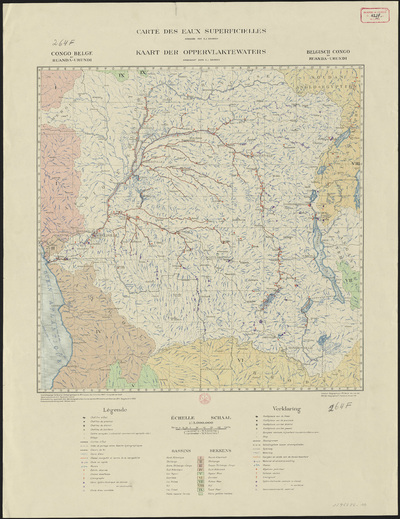
Congo belge et Ruanda-Urundi : carte des eaux superficielles = Belgisch Congo en Ruanda-Urundi : kaart der oppervlaktewaters
Authors, creators, collaborators : Devroey, Egide
Type of the represented object : Map
Permalink
https://hdl.handle.net/2268.1/3774
Détails
| Authors, creators, collaborators: | Devroey, Egide (authors) |
| Producers, publishers: | Bruxelles : Institut géographique militaire |
| Place of creation of the original object: | Bruxelles (Belgique) |
| First publication of the original object: | 1951 20th century Contemporary time (1789-20..) |
| Original object location: | Réseau des Bibliothèques |
| Identifiers: | 264F (cote ULiège) |
| Réseau des Bibliothèques: | Identifier: 990017964860502321 Barcode/Inventory no.: 1796486-10 Call number: 000264F |
| Original object language: | French Dutch, Flemish |
| Abstract: | Echelle 1:5 000 000 |
| Material, support of the original object: | Papier |
| Dimensions, weight or duration: | 46 x 46 cm |
| Physical description of the represented object : | 1 carte : couleurs |
| Description: | Légende reprenant les symboles utilisés pour représenter les chefs-lieux, les centres européens, les limites d'Etat, les crêtes de partage entre bassins hydrographiques, les chemins de fer, les cours d'eau, les chenals, les chutes d'eau, les marais, les usines, les échelles observées, les stations désaffectées, les limnigraphes, les bassins |
| Geographical Location represent or evoke: | Congo Belge (1908-1960) Rwanda Burundi |
| Keyword: | Eaux de surface -- Congo Belge (1908-1960); Eaux de surface -- Rwanda; Eaux de surface -- Burundi |
| CREF classifications: | Sciences de la terre et du cosmos |
| Classifications: | Physical, chemical, mathematical & earth Sciences => Earth sciences & physical geography |
| Part of: | Protected domain |
| Permalink: | https://hdl.handle.net/2268.1/3774 |
Items in DONum are protected by copyright, with all rights reserved, unless otherwise indicated.


