
Informations
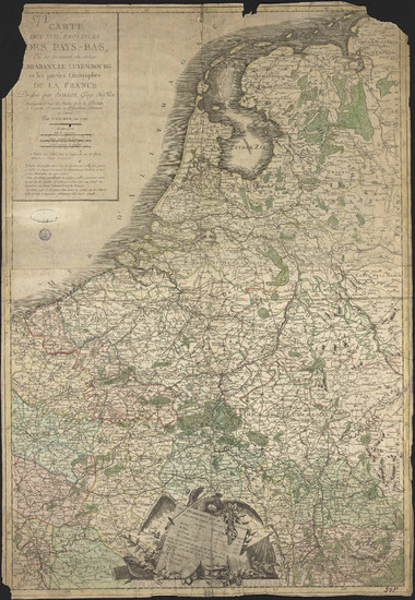
Carte des XVII provinces des Pays-Bas, où se trouvent en entier le Brabant, le Luxembourg et les parties limitrophes de la France. Dressée par Jaillot, géogr. du Roi. Augmentée de toutes les routes et de la division de la partie françoise en départemens, districts et cantons par Chaumier en 1792.
Authors, creators, collaborators : Jaillot, Alexis Hubert; Chaumier, C.-J.; Basset, Paul-André [éditeur et marchand d'estampes]
Type of the represented object : Map
Permalink
https://hdl.handle.net/2268.1/2693
Détails
| Authors, creators, collaborators: | Jaillot, Alexis Hubert (1632?-1712) (authors) Chaumier, C.-J. (17..-17..?) (engravers) Basset, Paul-André [éditeur et marchand d'estampes] (17..-184.) (editors) |
| Producers, publishers: | A Paris: chez Basset |
| Place of creation of the original object: | Paris (France) |
| First publication of the original object: | 1792 18th century Contemporary time (1789-20..) |
| Original object location: | Réseau des Bibliothèques |
| Collection: | Maps |
| Réseau des Bibliothèques: | Identifier: 990016865300502321 Barcode/Inventory no.: 701100719 Call number: R117A1F |
| Original object language: | French |
| Material, support of the original object: | Papier |
| Dimensions, weight or duration: | 80 x 56 cm |
| Physical description of the represented object: | 1 carte : couleurs. |
| Geographical Location represent or evoke: | Provinces Unies des Pays-Bas (1579-1795) |
| Keyword: | Provinces Unies des Pays-Bas (1579-1795) -- Cartes |
| Part of: | Public domain |
| Permalink: | https://hdl.handle.net/2268.1/2693 |

Items in DONum are protected by copyright, with all rights reserved, unless otherwise indicated.
