
Informations
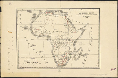
Les Chemins de fer construits, en construction ou projetés en Afrique.
Author(s), creator(s), collaborator(s) :
Type of the represented object : Map
Permalink
https://hdl.handle.net/2268.1/2671
Détails
| Editor: | Bruxelles : L. Manduau |
| Place of creation of the original object: | Bruxelles (Belgique) |
| First publication of the original object: | 1898 19th century Contemporary time (1789-20..) |
| Original object location: | Réseau des Bibliothèques |
| Collection: | Maps |
| Identifiant(s): | 51F (cote ULiège) ; 701100724 (code-barres ULiège) |
| Original object language: | French |
| Abstract: | Echelle 1:30 000 000 |
| Material, support of the original object: | Papier |
| Dimensions, weight or duration: | 29 x 40 cm |
| Physical description of the represented object : | 1 carte : couleurs. |
| Description: | Légende reprenant les symboles utilisés pour représenter les lignes de chemins de fer construites ou en construction et celles projetées |
| Geographical Location represent or evoke: | Afrique |
| Keyword: | Chemins de fer -- Afrique -- Cartes |
| CREF classification(s): | Sciences de la terre et du cosmos Bâtiments, génie civil, transports |
| Classification(s): | Physical, chemical, mathematical & earth Sciences => Earth sciences & physical geography Engineering, computing & technology => Civil engineering |
| Part of: | Public domain |
| Permalink: | https://hdl.handle.net/2268.1/2671 |

Items in DONum are protected by copyright, with all rights reserved, unless otherwise indicated.