
Informations
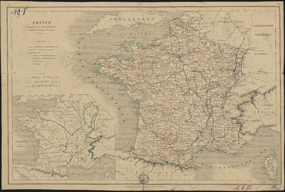
France divisée en 86 départements.
Author(s), creator(s), collaborator(s) : Leroy, Charles; Jenotte
Type of the represented object : Map
Permalink
https://hdl.handle.net/2268.1/2432
Détails
| Author(s), creator(s), collaborator(s): | Leroy, Charles (18..-....) (cartographer) Jenotte (18..-18..?) (engraver) |
| Editor: | Librairie classique Eugène Belin |
| Place of creation of the original object: | Paris (France) |
| First publication of the original object: | 19th century Contemporary time (1789-20..) |
| Original object location: | Réseau des Bibliothèques |
| Collection: | Maps |
| Identifiant(s): | 19F (cote ULiège) 701104194 (code-barres ULiège) |
| Original object language: | French |
| Abstract: | Echelle [1:3 898 600] Légende reprenant les symboles utilisés pour représenter les chemins de fer, les canaux, les chefs-lieux, les archevêchés, les évêchés |
| Material, support of the original object: | Papier |
| Dimensions, weight or duration: | 29 x 44 cm |
| Physical description of the represented object : | 1 carte : couleurs. |
| Geographical Location represent or evoke: | France |
| Keyword: | France -- Cartes |
| CREF classification(s): | Sciences de la terre et du cosmos Histoire |
| Classification(s): | Physical, chemical, mathematical & earth Sciences => Earth sciences & physical geography Arts & humanities => History |
| Part of: | Public domain |
| Permalink: | https://hdl.handle.net/2268.1/2432 |

Items in DONum are protected by copyright, with all rights reserved, unless otherwise indicated.