Informations
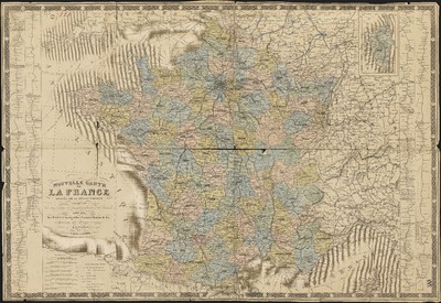
Nouvelle carte de la France divisée en 89 départements indiquant les chefs lieux d'arrondissements et de cantons ainsi que les rivières navigables, canaux, chemins de fer et parcours des bateaux à vapeur.
Author(s), creator(s), collaborator(s) : Frémin, Antoine-Remy
Type of the represented object : Map
Permalink
https://hdl.handle.net/2268.1/2430
Détails
| Author(s), creator(s), collaborator(s): | Frémin, Antoine-Remy (17..-18..) (cartographer) |
| Editor: | P. Marie & A. Bernard |
| Place of creation of the original object: | Paris (France) |
| First publication of the original object: | 1870 19th century Contemporary time (1789-20..) |
| Original object location: | Réseau des Bibliothèques |
| Collection: | Maps |
| Identifiant(s): | 17F (cote ULiège) 701104192 (code-barres ULiège) |
| Original object language: | French |
| Abstract: | Echelle [1:1 851 833] Légende reprenant les symboles utilisés pour représenter les chefs-lieux, les cantons, les routes, les chemins de fer, les lignes des bateaux à vapeur, les limites territoriales |
| Material, support of the original object: | Papier |
| Dimensions, weight or duration: | 57 x 82 cm |
| Physical description of the represented object : | 1 carte : couleurs. |
| Geographical Location represent or evoke: | France |
| Keyword: | France -- Cartes |
| CREF classification(s): | Sciences de la terre et du cosmos Histoire |
| Classification(s): | Sciences sociales & comportementales, psychologie => Geographie humaine & démographie Arts & humanities => History |
| Part of: | Public domain |
| Permalink: | https://hdl.handle.net/2268.1/2430 |
Items in DONum are protected by copyright, with all rights reserved, unless otherwise indicated.


