
Informations
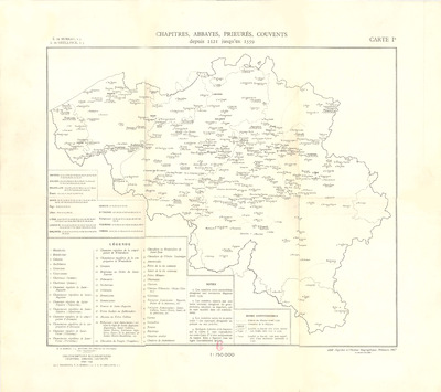
Chapitres, abbayes, prieurés, couvents depuis 1121 jusqu'en 1559
Author(s), creator(s), collaborator(s) : Moreau, Édouard de; De Ghellinck, Adrien
Type of the represented object : Map
Permalink
https://hdl.handle.net/2268.1/1496
Détails
| Author(s), creator(s), collaborator(s): | Moreau, Édouard de (1879-1952) (author) De Ghellinck, Adrien (author) |
| Editor: | Institut géographique militaire |
| Place of creation of the original object: | Bruxelles (Belgique) |
| First publication of the original object: | 1947 20th century Contemporary time (1789-20..) |
| Original object location: | Réseau des Bibliothèques |
| Identifiant(s): | 208F (cote ULiège) 709804923 (code-barres ULiège) |
| Original object language: | French |
| Dimensions, weight or duration: | 32 x 38 cm |
| Physical description of the represented object : | 1 carte : couleurs, entoilée |
| Description: | Légende reprenant les symboles utilisés pour représenter les limites des diocèses, les frontières, les localités Echelle 1:750 000 |
| Geographical Location represent or evoke: | Belgique |
| Keyword: | Abbayes -- Belgique -- Cartes; Chapitres cathédraux; collégiaux; etc. -- Belgique -- Cartes; Prieurés -- Belgique -- Cartes; Couvents -- Belgique -- Cartes |
| CREF classification(s): | Histoire |
| Classification(s): | Arts & humanities => History |
| Original object linked resource: | "Histoire de l'église de Belgique. Tome complémentaire 1, Circonscriptions ecclésiastiques, chapitres, abbayes, couvents avant 1559" de Edouard de Moreau |
| Part of: | Protected domain |
| Permalink: | https://hdl.handle.net/2268.1/1496 |

Items in DONum are protected by copyright, with all rights reserved, unless otherwise indicated.