
Informations
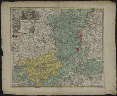
L'évêché et l'Etat de Liège avec les appartenances désignées dans les pais voisins. Délinéation nouvelle et exacte.
Authors, creators, collaborators :
Type of the represented object : Map
Permalink
https://hdl.handle.net/2268.1/14369
Détails
| Producers, publishers: | [Augsbourg] : Au dépens de Tobie Conrad Lotter, géographe |
| Place of creation of the original object: | Augsbourg (Allemagne) |
| First publication of the original object: | [entre 1740 et 1775?] 18th century Modern times (1492-1789) |
| Original object location: | Réseau des Bibliothèques |
| Réseau des Bibliothèques: | Identifier: 9923460540502321 Barcode/Inventory no.: 709504095 Call number: R209A1F |
| Original object language: | French |
| Material, support of the original object: | Papier |
| Physical description of the represented object : | Echelle [environ 1:240 000]. 4 milles de France à 20 au degré 1 carte : couleur ; 50 x 58 cm |
| Description: | Echelle donné en trois anciennes mesures : milles d'Allemagne en degré, milles de France en degré, milles d'Italie et d'Angleterre en degré
Armoiries de la Principauté et celles de l'évêque Georges Louis de Berg brochant sur le tout Titre dans un cartouche orné |
| Keyword: | Liège (Principauté) ; Cartes anciennes; Liège (Ecclesiastical principality); Early maps |
| Classifications: | Physical, chemical, mathematical & earth Sciences => Earth sciences & physical geography |
| Other contributors: | Lotter, Tobias Conrad [imprimeur] (1717-1777) (printers-booksellers) |
| Part of: | Public domain |
| Permalink: | https://hdl.handle.net/2268.1/14369 |

Items in DONum are protected by copyright, with all rights reserved, unless otherwise indicated.
