
Informations
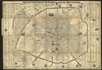
Nouveau plan complet de Paris avec ses fortifications divisé en 12 arrondissements et 48 sections avec les principaux monuments en élévation, donnant la distance légale en mètres des forts détachés aux murs d'enceinte et aux murs d'octroi indiquant la population et les fêtes patronales des environs de Paris.
Author(s), creator(s), collaborator(s) : Henriot, J. N.
Type of the represented object : Plan (map)
Permalink
https://hdl.handle.net/2268.1/3807
Détails
| Author(s), creator(s), collaborator(s): | Henriot, J. N. (engraver) |
| Editor: | Paris : Chez A. Bes et F. Dubreuil |
| Place of creation of the original object: | Paris (France) |
| First publication of the original object: | 1852 19th century Contemporary time (1789-20..) |
| Original object location: | Réseau des Bibliothèques |
| Collection: | Maps |
| Identifiant(s): | 001012F (cote ULiège) 700203616 (code-barres ULiège) |
| Original object language: | French |
| Abstract: | 1:1000 |
| Material, support of the original object: | Papier |
| Dimensions, weight or duration: | 60 x 88 cm |
| Physical description of the represented object : | 1 plan. Gravure sur acier. |
| Description: | Légende : Table alphabétique des noms des rues. - Plan repliable dans son livret. |
| Geographical Location represent or evoke: | Paris (France) |
| CREF classification(s): | Sciences de la terre et du cosmos |
| Classification(s): | Physical, chemical, mathematical & earth Sciences => Earth sciences & physical geography |
| Part of: | Public domain |
| Permalink: | https://hdl.handle.net/2268.1/3807 |

Items in DONum are protected by copyright, with all rights reserved, unless otherwise indicated.