Informations
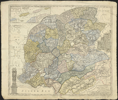
Frisiae dominium vernacule Friesland, verdeeld in de Hoofd-deelen van Oostergoo, Westergoo en Sevenwolde[n]. Als ook der XI steden zynde noch onderscheiden de XXX Grietenijen naar de nieuwste afmetingen getekend en uitgegeven door François Halma, te Leeuwarden met privilegie 1718.
Authors, creators, collaborators : Halma, François
Type of the represented object : Map
Permalink
https://hdl.handle.net/2268.1/3787
Détails
| Authors, creators, collaborators: | Halma, François (1653-1722) (authors) |
| Producers, publishers: | Te Amsterdam : by I. Covens en zoon |
| Place of creation of the original object: | Amsterdam (Pays-Bas) |
| First publication of the original object: | 1718 18th century Modern times (1492-1789) |
| Original object location: | Réseau des Bibliothèques |
| Collection: | Maps |
| Réseau des Bibliothèques: | Identifier: 990017976280502321 Barcode/Inventory no.: 1797628-10 Call number: R152A1F |
| Original object language: | Dutch, Flemish |
| Abstract: | Echelle [1:130 000] |
| Material, support of the original object: | Papier |
| Dimensions, weight or duration: | 52 x 60 cm |
| Physical description of the represented object : | 1 carte : couleurs |
| Description: | Carte jointe : Friesse Eilanden met de omlegende zee plaaten enz. (Echelle 1:350 000)
Légende reprenant les symboles pour représenter les villes, les villages, les forts, les écoles |
| Geographical Location represent or evoke: | Frise, Province de (Pays-Bas) |
| CREF classifications: | Sciences de la terre et du cosmos |
| Classifications: | Physical, chemical, mathematical & earth Sciences => Earth sciences & physical geography |
| Part of: | Public domain |
| Permalink: | https://hdl.handle.net/2268.1/3787 |
Items in DONum are protected by copyright, with all rights reserved, unless otherwise indicated.


