Informations
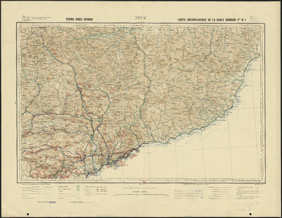
Carte archéologique de la Gaule romaine. 1, Nice.
Authors, creators, collaborators : Blanchet, Jules-Adrien
Type of the represented object : Map
Permalink
https://hdl.handle.net/2268.1/3775
Détails
| Other title: | Forma orbis romani |
| Authors, creators, collaborators: | Blanchet, Jules-Adrien (1866-1957) (editors) |
| Producers, publishers: | [Paris] : [Ernest Leroux] |
| Place of creation of the original object: | Paris (France) |
| First publication of the original object: | 1931 20th century Contemporary time (1789-20..) |
| Original object location: | Réseau des Bibliothèques |
| Original object language: | French |
| Material, support of the original object: | Papier |
| Dimensions, weight or duration: | 46 x 67 cm |
| Physical description of the represented object : | 1 carte : couleurs |
| Description: | Légende reprenant les symboles utilisés pour représenter les routes, les chemins, les sentiers, les préfectures, les sous-préfectures, les cantons, les communes, les hameaux, les forts, les batteries, les chemins de fer, les cours d'eaux, les canaux, les lacs et étangs, les limites territoriales L'ouvrage n'est plus présent dans les collections papier de l'ULiège Library |
| Geographical Location represent or evoke: | Gaule |
| CREF classifications: | Sciences de la terre et du cosmos Arts |
| Classifications: | Physical, chemical, mathematical & earth Sciences => Earth sciences & physical geography Arts & humanities => Archaeology |
| Part of: | Protected domain |
| Permalink: | https://hdl.handle.net/2268.1/3775 |
Items in DONum are protected by copyright, with all rights reserved, unless otherwise indicated.


