
Informations
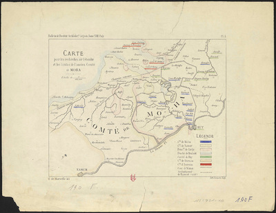
Carte pour les recherches sur l'étendue et les limites de l'ancien Comté de Moha.
Authors, creators, collaborators : Marneffe, E. de
Type of the represented object : Map
Permalink
https://hdl.handle.net/2268.1/3747
Détails
| Authors, creators, collaborators: | Marneffe, E. de (authors) |
| Producers, publishers: | Liège : Lith. Cremetti |
| Place of creation of the original object: | Liège (Belgique) |
| First publication of the original object: | 1879 19th century Contemporary time (1789-20..) |
| Original object location: | Réseau des Bibliothèques |
| Collection: | Maps |
| Identifiers: | 190F (cote ULiège) 1745931-10 (code-barres ULiège) |
| Réseau des Bibliothèques: | Identifier: 990017459310502321 |
| Original object language: | French |
| Abstract: | Echelle 1:160 000 |
| Material, support of the original object: | Papier |
| Dimensions, weight or duration: | 18 x 24 cm |
| Physical description of the represented object: | 1 carte : couleurs. |
| Description: | Légende reprenant les couleurs utilisées pour représenter les différents Comtés. |
| Geographical Location represent or evoke: | Moha (Belgique) |
| Original object is part of: | "Bulletin de l'Institut Archéologique Liégeois", vol. XIIII, pl. 1 |
| Part of: | Public domain |
| Permalink: | https://hdl.handle.net/2268.1/3747 |

Items in DONum are protected by copyright, with all rights reserved, unless otherwise indicated.
