
Informations
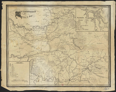
Carte itinéraire des environs de Spa.
Authors, creators, collaborators :
Type of the represented object : Map
Permalink
https://hdl.handle.net/2268.1/3745
Détails
| Producers, publishers: | Verviers : Frères Hahn |
| Place of creation of the original object: | Verviers (Belgique) |
| First publication of the original object: | 1845? 19th century Contemporary time (1789-20..) |
| Original object location: | Réseau des Bibliothèques |
| Collection: | Maps |
| Identifiers: | 188F (cote ULiège) 709504165 (code-barres ULiège) |
| Réseau des Bibliothèques: | Identifier: 990017459490502321 |
| Original object language: | French |
| Abstract: | Echelle [1:92 300] |
| Material, support of the original object: | Papier |
| Dimensions, weight or duration: | 34 x 44 cm |
| Physical description of the represented object: | 1 carte |
| Description: | Encart : Plan de Spa.
Légende reprenant les symboles utilisés pour représenter les villes, les bourgs, les villages, les hameaux, les châteaux, les masures, les fermes, les points de vue, les sources minérales, les grandes routes, les chemins vicinaux. |
| Geographical Location represent or evoke: | Spa (Belgique) |
| Part of: | Public domain |
| Permalink: | https://hdl.handle.net/2268.1/3745 |

Items in DONum are protected by copyright, with all rights reserved, unless otherwise indicated.
