
Informations
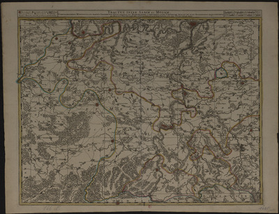
Tractus inter Sabim et Mosam comprehendens meridionales partes Leodiensis episcopatus et Namurcensis comitatus cum Condrusii tractu et aliis regionibus adjacentibus per Nicolaum Visscher Amst: Bat: cum privil: ordin: general: Belgii Foederati.
Authors, creators, collaborators : Visscher, Nicolas
Type of the represented object : Map
Permalink
https://hdl.handle.net/2268.1/3715
Détails
| Authors, creators, collaborators: | Visscher, Nicolas (1618-1679) (authors) |
| Producers, publishers: | Amst[elodami] Bat[avorum] : nunc apud Petrum Schenk Junior |
| Place of creation of the original object: | Amsterdam (Pays-Bas) |
| First publication of the original object: | [entre 1730 et 1770?] 18th century Modern times (1492-1789) |
| Original object location: | Réseau des Bibliothèques |
| Collection: | Maps |
| Réseau des Bibliothèques: | Identifier: 990017236280502321 Barcode/Inventory no.: 709504086 Call number: 000166F |
| Original object language: | French Latin |
| Material, support of the original object: | Papier |
| Dimensions, weight or duration: | 49 x 58 cm |
| Physical description of the represented object: | 1 carte : couleurs. Echelle [environ 1:130 000] |
| Description: | Légende reprenant les symboles utilisés pour représenter les villes fortifiées, les villages, les quartiers, les châteaux, les monastères, les chapelles, les forts, les moulins à eau |
| Keyword: | Liège (Principauté) -- Cartes; Namur (Comté) -- Cartes; Condroz (Belgique) -- Cartes; Liège (Ecclesiastical principality); Cartes anciennes.; Early maps. |
| Other contributors: | Schenck, Pieter junior (1698?-1775) (printers-booksellers) |
| Part of: | Public domain |
| Permalink: | https://hdl.handle.net/2268.1/3715 |

Items in DONum are protected by copyright, with all rights reserved, unless otherwise indicated.
