Informations
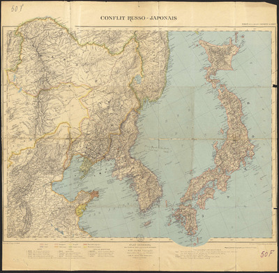
Conflit russo-japonais.
Authors, creators, collaborators : Aïtoff, David
Type of the represented object : Map
Permalink
https://hdl.handle.net/2268.1/2670
Détails
| Authors, creators, collaborators: | Aïtoff, David (1854-1933) (cartographers) |
| Producers, publishers: | Paris : Erhard Frères |
| Place of creation of the original object: | Paris (France) |
| First publication of the original object: | 1904 20th century Contemporary time (1789-20..) |
| Original object location: | Réseau des Bibliothèques |
| Réseau des Bibliothèques: | Identifier: 990016873810502321 Barcode/Inventory no.: 701100728 Call number: 000050F |
| Original object language: | French |
| Abstract: | Echelle 1:5 000 000 |
| Material, support of the original object: | Papier |
| Dimensions, weight or duration: | 45 x 56 cm |
| Physical description of the represented object : | 1 carte : couleurs. |
| Description: | Tirage à part de l'Atlas universel de Vivien de Saint-Martin, feuille IV
Légende reprenant les couleurs utilisés pour représenter le Japon, la Corée, la Mandchourie, la Chine, la Mongolie, l'Empire russe, les possessions anglaises et celles allemandes, ainsi que les symboles utilisés pour représenter les villes, capitales, chefs-lieux du Japon, de la Corée, de la Chine et de la Mandchourie |
| Geographical Location represent or evoke: | Japon Corée Mandchourie (Chine ; 1...-1931) Chine Mongolie Russie, Empire de (1547-1922) |
| Keyword: | Guerre russo-japonaise (1904-1905) -- Cartes |
| CREF classifications: | Sciences de la terre et du cosmos Histoire |
| Classifications: | Physical, chemical, mathematical & earth Sciences => Earth sciences & physical geography Arts & humanities => History |
| Part of: | Public domain |
| Permalink: | https://hdl.handle.net/2268.1/2670 |
Items in DONum are protected by copyright, with all rights reserved, unless otherwise indicated.


