
Informations
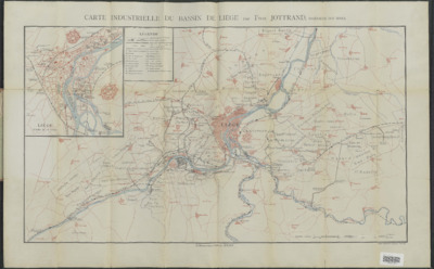
Carte industrielle du bassin de Liége
Auteurs, créateurs, collaborateurs : Jottrand, Félix
Type d'objet représenté : Carte
URL permanente
https://hdl.handle.net/2268.1/14214
Détails
| Auteurs, créateurs, collaborateurs: | Jottrand, Félix (1863-1907) (auteurs) |
| Producteurs, éditeurs: | Mons : H. Manceaux ; Bruxelles : Institut national de géographie |
| Lieu de création de l'objet original: | Mons (Belgique) |
| Première publication ou diffusion de l'objet original: | [entre 1890 et 1905?] 19e siècle Epoque contemporaine (1789-20..) |
| Lieu de conservation de l'objet original: | Réseau des Bibliothèques |
| Réseau des Bibliothèques: | Identifiant: 990015119190502321 Code-barres/N° inventaire: 700503755 Cote: XIII.178.015 [16°] |
| Langue de l'objet original: | Français |
| Matériau, support de l'objet original: | Papier |
| Dimensions, durée ou poids: | 78 x 59 cm. |
| Description physique de l'objet représenté: | 1 carte |
| Description: | Echelle : 1/40000 |
| Mots-clés: | Cartes; Liège (Belgique); Industrie -- Liège (Belgique); Industries; Belgium -- Liège |
| Fait partie du: | Domaine public |
| URL permanente: | https://hdl.handle.net/2268.1/14214 |

Les reproductions numériques disponibles sur DONum sont en faible résolution, facilitant le téléchargement. Des fichiers de haute qualité peuvent être obtenus sur conditions, via notre formulaire de contact.
Les documents disponibles sur DONum peuvent être protégés par le droit d'auteur. Ils sont soumis aux règles habituelles de bon usage.
