
Informations
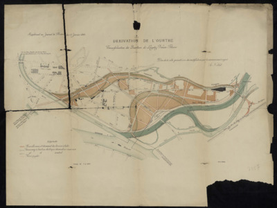
Déviation de l'Ourthe : transformations des quartiers de Longdoz, Vennes, Fétinne.
Authors, creators, collaborators :
Type of the represented object : Map
Permalink
https://hdl.handle.net/2268.1/10442
Détails
| Producers, publishers: | [Liège] : Lith. A. Bénard |
| Place of creation of the original object: | Liège (Belgique) |
| First publication of the original object: | 1892 19th century Contemporary time (1789-20..) |
| Original object location: | Réseau des Bibliothèques |
| Identifiers: | 000735F (cote ULiège) 709504403 (code-barres ULiège) |
| Réseau des Bibliothèques: | Identifier: 990000090330502321 |
| Original object language: | French |
| Material, support of the original object: | Papier |
| Dimensions, weight or duration: | 50 x 66 cm |
| Physical description of the represented object: | 1 carte |
| Description: | Supplément au journal "La Meuse" du 13 janvier 1892.
Légende reprenant les signes utilisées pour représenter la nouvelle voirie et lotissement des terrains à bâtir, le tramway à traction électrique demandé en concession, le tramway à traction électrique éventuel, la percée projetée. Echelle : 1:5000 |
| Keyword: | Ourthe (Belgique; cours d'eau); Liège (Belgique; province); Carte |
| Part of: | Public domain |
| Permalink: | https://hdl.handle.net/2268.1/10442 |

Items in DONum are protected by copyright, with all rights reserved, unless otherwise indicated.
