
Informations
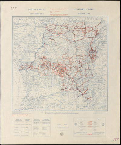
Congo belge : carte routière
Authors, creators, collaborators : Belgique. Ministère des colonies. Service cartographique
Type of the represented object : Map
Permalink
https://hdl.handle.net/2268.1/2709
Détails
| Translated title: | Belgisch Congo wegenkaart |
| Authors, creators, collaborators: | Belgique. Ministère des colonies. Service cartographique (authors) |
| Producers, publishers: | Bruxelles : Institut cartographique militaire |
| Place of creation of the original object: | Bruxelles (Belgique) |
| First publication of the original object: | 1939 20th century Contemporary time (1789-20..) |
| Original object location: | Réseau des Bibliothèques |
| Réseau des Bibliothèques: | Identifier: 990016814850502321 Barcode/Inventory no.: 701006373 Call number: 000078F |
| Original object language: | French |
| Abstract: | Echelle 1:5 000 000 |
| Material, support of the original object: | Papier |
| Dimensions, weight or duration: | 49 x 50 cm |
| Physical description of the represented object: | 1 carte : couleurs. |
| Description: | Les six provinces du Congo belge portent le nom de leur Chef-lieu.
Légende reprenant les symboles utilisés pour les moyens de communication et les subdivisions administratives ainsi que le réseau routier. Annexe au mémoire "Le réseau routier au Congo belge et le Urunda-Burundi" par E. J. Devroey |
| Geographical Location represent or evoke: | Congo (République démocratique) |
| Keyword: | Congo (République démocratique) -- Cartes routières |
| Part of: | Public domain |
| Permalink: | https://hdl.handle.net/2268.1/2709 |

Items in DONum are protected by copyright, with all rights reserved, unless otherwise indicated.
